
Coral Springs Mobility Hub
Project Description
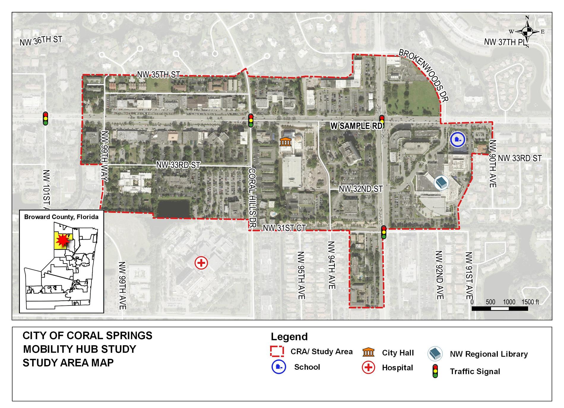
The Broward MPO 2035 Long Range Transportation Plan identified the area within Coral Springs near the intersection of University Drive and W. Sample Road as a Mobility Hub. The Broward MPO allocated funding for a Mobility Hub Master Plan which was completed November 20, 2020.
The Master Plan produced site-specific work to further the Mobility Hub planning, design and implementation of improvements within the project area.
The Coral Springs Commission passed a resolution of support for the Mobility Hub Master Plan on April 7, 2021.
General Location Map
 Resoures and Documents
Cypress Creek Mobility Hub
Project Description
The Cypress Creek Mobility Hub is the second largest commercial district in Broward County, and home to a Tri-Rail Station, Tri-Rail shuttles, Broward County Transit bus service, and easy access to I-95. The Broward MPO, in partnership with the South Florida Regional Transportation Authority (SFRTA) who operate Tri-Rail, Florida Department of Transportation (FDOT), Broward County, City of Fort Lauderdale and City of Oakland Park are looking to identify infrastructure improvements and joint development opportunities in the area of the Cypress Creek Mobility Hub. The goal of this hub is to plan efficient transportation connections that will spur continued growth and development, enhance walkability, and promote the use of multiple modes of transportation within this Mobility Hub.
The Cypress Creek Mobility Hub Master Plan will identify privately funded development opportunities and infrastructure improvements within the mobility hub, including:
- Development opportunities on publicly owned land
- Improved access to the Tri-Rail station for all transportation modes
- Enhanced pedestrian connections
- Improved bus circulation and access
- Improved connection to the Fort Lauderdale Executive Airport
- Evaluation of enhanced Broward County Transit, Tri-Rail Shuttle service, and Express Buses
- Evaluation of public parking needs within the study area.
- Evaluation of Complete Streets implementation within the study area.
- Traffic synchronization
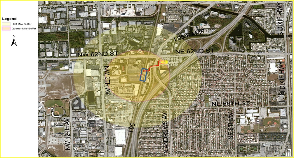
General Location Map
Project Improvements
The Cypress Creek Mobility Hub construction project consists of improvements along three roads in the study area:
- Cypress Creek Road from Powerline Road to Tri-rail Railroad Tracks
- Andrews Avenue
- NW 59th Court from Powerline Road to the Tri-Rail Entrance
Improvement throughout the project consisted of enhancing mobility, safety, lighting, and landscaping along all project roadways. For each roadway the following improvements will be constructed:
- Cypress Creek Rd.
- ADA improvements
- 10’ shared use paths on both sides of road
- Milling and resurfacing and new pavement markings
- Andrews Way
- Tri-Rail wayfinding Pylon at Tri-Rail Entrance
- New mid-block crossings
- ADA improvements
- 5’ sidewalks on both sides of road
- Milling and resurfacing and new pavement markings
- NW 59th Ct.
- Milling and resurfacing
- Sidewalks on both sides of road (6’ on north side, 10’ on southside)
- ADA improvements
- Tri-Rail wayfinding Pylon at Tri-Rail Entrance
Resoures and Documents
- Technical Memorandum #1- Existing Conditions
- Technical Memorandum #2- Core Document for Future RFP/RFQ
- Technical Memoradum #3- Development Strategies
- Market Study / Economic Analysis Report
- Streetscape Concepts
- Kick Off Meeting Agenda
- January 2015 Agenda
- February 2015 Agenda
- March 2015 Agenda
- April 2015 Agenda
- May 2015- No Meeting
- June 2015 Agenda
- July 2015 Agenda
- August 2015 Agenda
- September 2015- No Meeting
- October 2015 Agenda (Final Meeting)
- Kick Off Meeting Minutes
- January 2015 Minutes
- February 2015 Minutes
- March 2015 Minutes
- April 2015 Minutes
- May 2015- No Meeting
- June 2015 Minutes
- July 2015 Minutes
- August 2015 Minutes
- September 2015- No Meeting
- October 2015 Minutes
- Kickoff Presentation (December 9, 2014)
- Cypress Creek Mobility Hub Master Plan
- March Progress Report PowerPoint
- April Progress Report PowerPoint
- Streetscape Concepts
- July Progress Report PowerPoint
- August Progress Report PowerPoint
- Final Meeting- Finding and Recommendations
Related Projects
- I-95 South of Commercial Blvd to North Cypress Creek Road Project Development & Environment Study- Completed May 16, 2019
The Florida Department of Transportation (FDOT) is seeking infrastructure solutions for capacity and safety improvements along I-95, the interchanges at Commercial Boulevard and Cypress Creek Road and the adjacent intersections to both interchanges. The project area of influence along I-95 extends from just south of Prospect Road to just north of McNab Road for approximately 2 miles. The project includes an evaluation of the existing roadway and roadside to identify deficiencies or items needing improvement to current FDOT standards. - For more information, please visit the project website at www.95commercialtocypress.com
- Uptown Urban Village Project
The City of Fort Lauderdale’s Uptown Urban Village (Uptown) Project is a planning project derived from an August 2014 Urban Land Institute Technical Advisory Panel (TAP) report that identified strategies in creating a more livable urban village core for the Uptown area. Uptown is generally described as the area in and around the Fort Lauderdale Executive Airport, with the area’s core flanked by C-14 canal and McNab Road to the north, 57th Street to the south, Powerline Road to the west, and I-95 to the east. The overall intent is to establish a planning framework to guide future growth in the area by amending the current land use designations to a single land use designation that supports a mix of uses and multi-modal development. The project goals also include the development of a form-based code to regulate the built form consistent with the new underlying land use thereby making the area a multi-modal, walkable, pedestrian-friendly, mixed-use, developed area.
For more information, please visit the project website at www.fortlauderdale.gov/departments/sustainable-development/urban-design-and-planning/planning-initiatives/uptown-urban-village-project
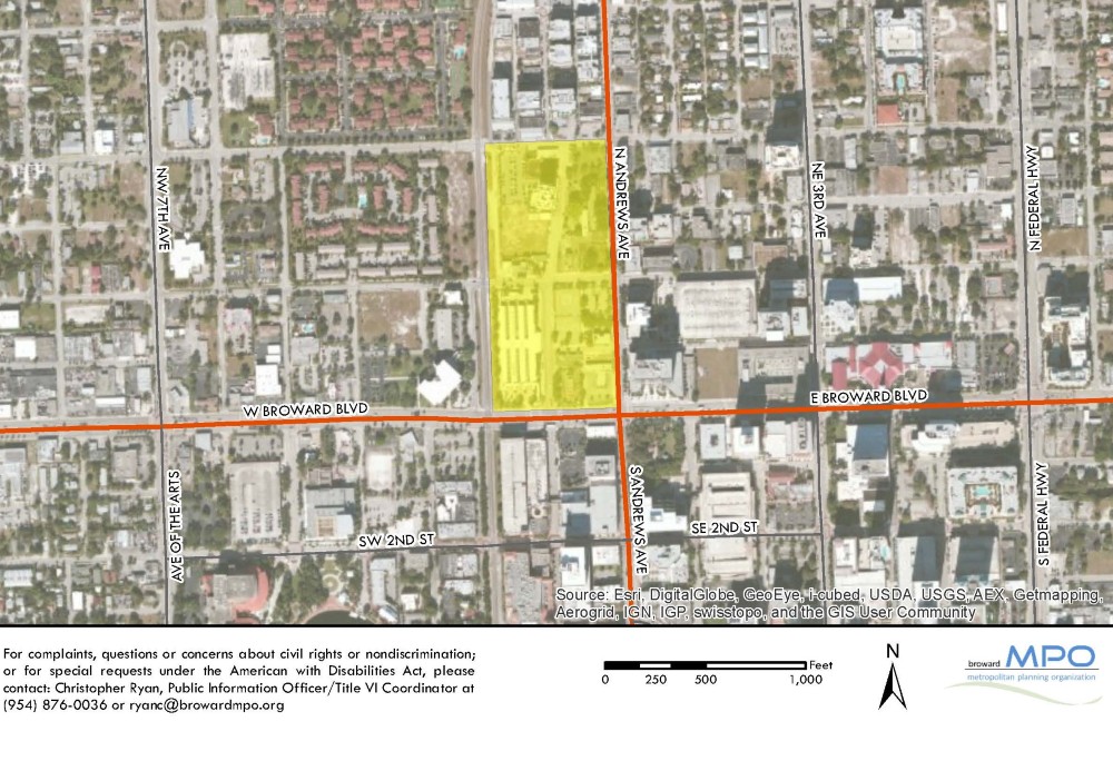
The Downtown Fort Lauderdale Mobility Hub is the first Hub that the Broward MPO, in partnership with the City of Fort Lauderdale, has funded for infrastructure improvements . This Mobility Hub is centrally located in downtown Fort Lauderdale which is an area actively redeveloping because of its close proximity to the downtown business district, government centers and access to transit.
On September 13, 2019, the City of Fort Lauderdale hosted the groundbreaking celebration that kickstarted construction of the $3.5 million project. Infrastructure improvements include sidewalks, bike lanes, lighting, drainage and landscaping, repaving and ADA improvements.
The purpose of the Downtown Mobility Hub is to create infrastructure that is supportive of mixed-use development/redevelopment and to seamlessly integrate different modes of transportation (walking, bicycling, transit and automobiles) that maximize first and last mile connectivity while being consistent with the City of Fort Lauderdale’s vision for the Downtown area. The Downtown Mobility Hub is a multi-block area that will connect various transportation choices including:
- Regional express bus service
- Local bus service to points throughout Broward County
- Community shuttle bus connections
- Brightline inter-city passenger rail between Downtown Miami and Orlando
- Future commuter rail service
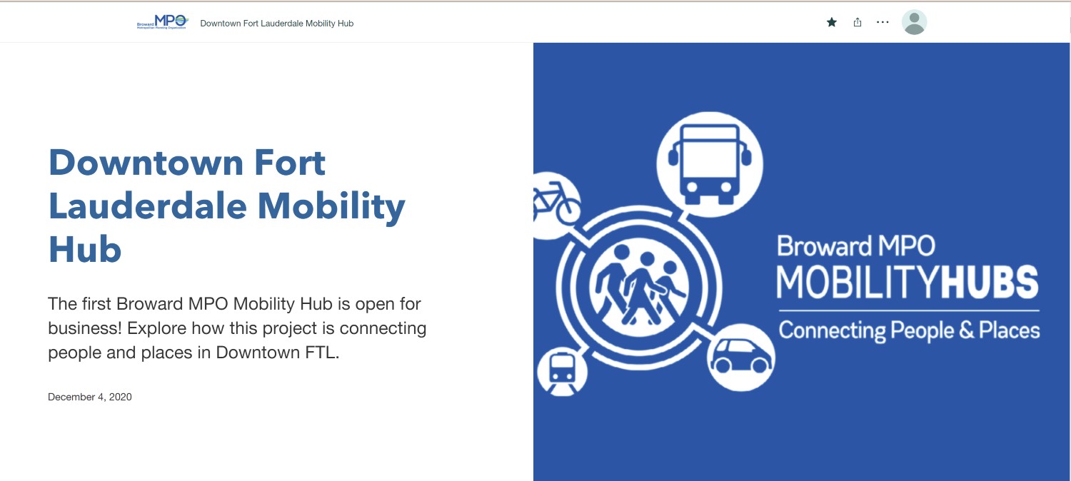
The Downtown Mobility Hub is open to the public!
CLICK HERE, to view the Downtown Fort Lauderdale Mobility Hub Story Map.
General Location Map
Resoures and Documents
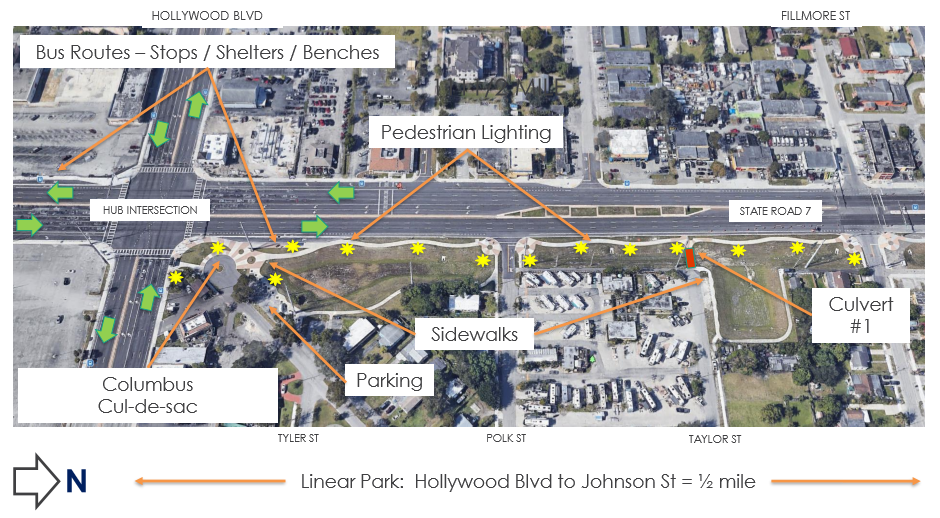
The Broward MPO has allocated $1 million dollars to advance the Hollywood Boulevard / State Road 7 (SR7) study recommendations into design and construction. The Hollywood Mobility Hub study was completed in January 2018. The recommendations include a combination of safety, transit, and pedestrian connectivity elements at the intersection of Hollywood Boulevard and SR7 and the surrounding area.
The Hollywood Mobility Hub improvements will include bus shelters, pedestrian-scale lighting, pedestrian and bicycle connections to the neighborhoods, and other transit amenities. This project will complement other investments such as FDOT's roadway expansion along SR7 and the City of Hollywood's linear park north of the Mobility Hub location.
As of October 2020, our partners at the City of Hollywood have hired a design firm to work on this project. Project design is currently underway and construction is anticipated to start in the Summer of 2022.
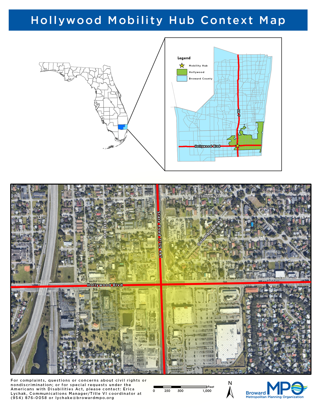
General Locations Map
Resoures and Documents
- Mobility Hub Overview FINAL - Jan. 2018
- Market Analysis FINAL - Jan. 2018
- Planning Context FINAL - Jan. 2018
- Planning Framework FINAL - Jan. 2018
- Project Elements FINAL - Jan. 2018
- Implementation Strategy FINAL - Jan. 2018
- Composite Framework FINAL - Jan. 2018
- Concept Renderings FINAL - Feb. 2018
- Hollywood Boulevard/State Road 7 Mobility Hub Workshop Presentation - June 29, 2017
- Hollywood Mobility Hub Public Meeting October 25th, 2021
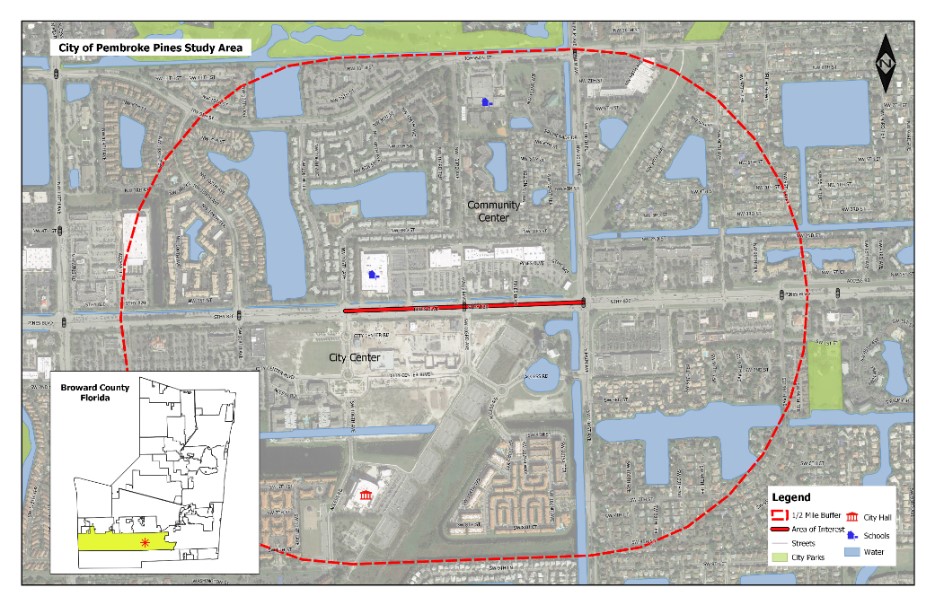
The Broward MPO 2035 Long Range Transportation Plan identified the area within Pembroke Pines near the intersection of Pines Boulevard (SR 820) and 103rd Avenue (one block west of the intersection of Pines Boulevard and Palm Avenue adjacent to the City Center development) as a Mobility Hub. The Broward MPO allocated funding for a Mobility Hub Master Plan which was completed on November 20, 2020.
The Master Plan produced site-specific work to further the Mobility Hub planning, design and implementation of improvements within the project area.
The Pembroke Pines Commission passed a resolution of support for the Mobility Hub Master Plan on December 16, 2020.
General Location Map
Resoures and Documents
- Pembroke Pines Mobility Hub Master Plan Overview
- Pembroke Pines Mobility Hub Master Plan Planning Context
- Pembroke Pines Mobility Hub Master Plan Market Analysis
- Pembroke Pines Mobility Hub Master Plan Planning Framework
- Pembroke Pines Mobility Hub Master Plan Project Elements
- Pembroke Pines Mobility Hub Master Plan Implementation Strategy
- City of Pembroke Pines Joint Advisory Board Workshop - November 8, 2018
- City of Pembroke Pines Economic Development and Planning and Zoning Board - November 10, 2019
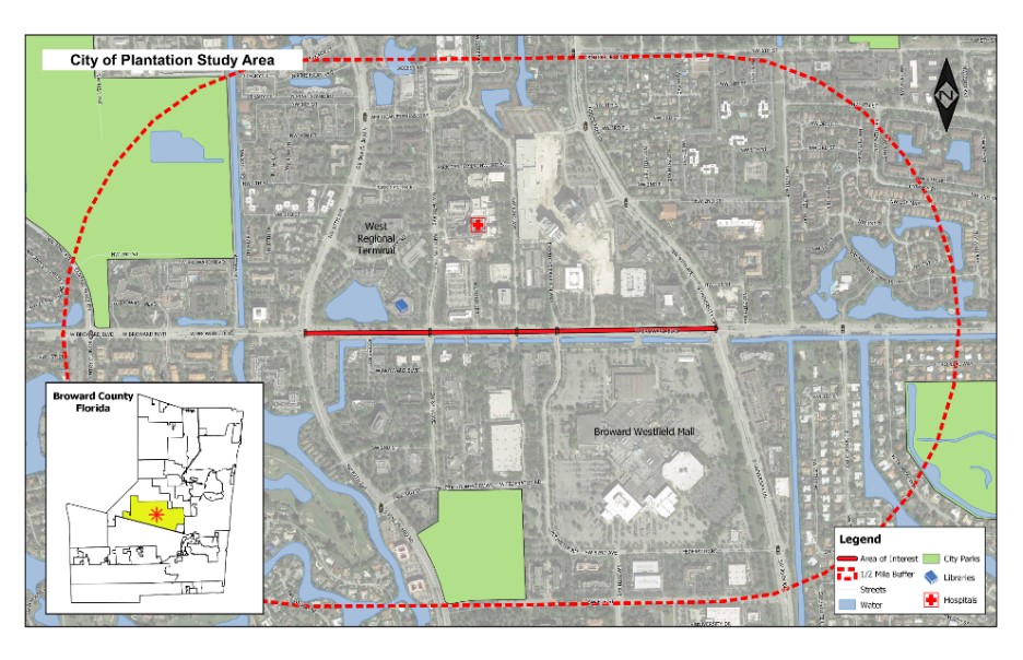
The Broward MPO 2035 Long Range Transportation Plan identified the area within Midtown Plantation near the intersection of Broward Boulevard and University Drive as a Mobility Hub. The Broward MPO allocated funding for a Mobility Hub Master Plan which was completed on June 30, 2020.
The Master Plan produced site-specific work to further the Mobility Hub planning, design and implementation of improvements within the project area.
General Location Map
Resoures and Documents
- Plantation Mobility Hub Master Plan Overview
- Plantation Mobility Hub Master Plan Planning Context
- Plantation Mobility Hub Master Plan Market Analysis
- Plantation Mobility Hub Master Plan Planning Framework
- Plantation Midtown Advisory Board Meeting - October 17, 2018, CLICK HERE for minutes
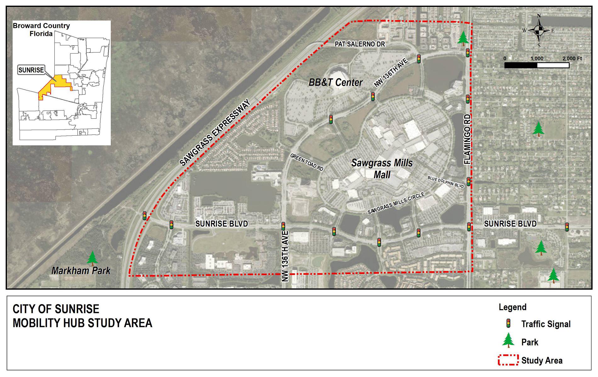
The Sunrise Mobility Hub location was selected for a Master Plan to identify appropriate near-term MPO investments and long-term implementation strategies, based on its future role in the transit network and recent development and redevelopment activity that will impact future mobility needs.
The Sunrise Mobility Hub Master Plan reflects the following intentions of the Mobility Hubs initiative, which are both regional and local in scope.
REGIONAL / COUNTYWIDE
- Promote a variety of transportation choices that are convenient
- Promote visibility of alternative modes
- Focus on locations where modes can seamlessly converge
- Improve access to employment
- Increase access to shops and amenities
- Strengthen the social fabric
LOCAL / MOBILITY HUB VICINITY
- Invest in near-term priorities
- Provide safe access to the multimodal network
- Increase usage and visibility of the multimodal network
- Activate the public realm
- Align with local priorities
- Support long-term strategies
- Coordinate planning/design needs with 2045 Metropolitan Transportation Plan
- Support mobility-friendly policies and standards for all users
- Identify appropriate phasing
- Formalize sponsor/partner commitments
General Location Map
Resoures and Documents
For More Information
Please contact Amanda Christon at (954) 876-0078 or christona@browardmpo.org to learn more about the Broward MPO and what they are working on in your community.